Decision-Scale Modeling of Energy Expansion Costs and Benefits in the Southeastern United States
Overview
The need to establish affordable, secure, and resilient energy supplies is of paramount importance as energy demands grow because of shifts in industry, population, consumer behavior, technology development, and other drivers. Energy planners and decision-makers, spanning national to local levels, have long faced the same basic questions: What infrastructure should be built? Where? And when? Answering these questions has become more challenging in a rapidly changing world, particularly when considering the multitude of voices needed to ensure that solutions are robust, resilient, durable, and lasting. All new energy infrastructure scenarios come with unique trade-offs, with benefits and risks across multiple social, economic, and environmental dimensions.
Developed by the US Department of Energy’s (DOE’s) Oak Ridge National Laboratory (ORNL), Action Relevant Modeling and Decision Analysis (ARMADA) quantifies those trade-offs through an innovative approach to integrated systems modeling that enables iteration between scenario development and geospatial analysis at “decision-relevant scales”—sufficiently granular for placing hypothetical infrastructure assets on the land surface (at 3 × 3 m to 4 × 4 km resolution). ARMADA represents strategic infrastructure options for the future, maps them across various spatial units (e.g., counties, watersheds, Census tracts, properties, and protected areas), and quantifies the multidimensional effects of constructing and operating infrastructure assets, grids, and networks using metrics that decision-makers care about.
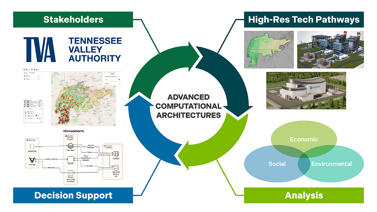
ARMADA aims to fill a gap in macro-energy systems and multisector dynamics research by employing a highly granular geographic representation of environmental, socioeconomic, and infrastructural systems and using high-resolution, data-intensive mechanistic models to study resilience across multiple dimensions. The system leverages advanced computational architectures, software engineering, data storage, and visualization techniques.
Results/Accomplishments
ARMADA starts where most macro-energy systems and multisector dynamics modeling frameworks stop. Multidimensional sustainability and resilience metrics are calculated through forward-looking analyses that integrate more than a dozen high-resolution mechanistic models—many operating in high-performance computing (HPC) environments—from the following five ORNL directorates.
• Energy Science and Technology Directorate (ESTD)
• Biological and Environmental Systems Science Directorate (BESSD)
• Computing and Computational Sciences Directorate (CCSD)
• National Security Sciences Directorate (NSSD)
• Fusion and Fission Energy and Science Directorate (FFESD)
Analyses are conducted across regions and utility service areas at subkilometer and meter-scale resolution. Quantification extends from today to 2050 under alternative scenarios that consider deployment of fossil, nuclear, and renewable energy technologies. These scenarios use aggregated outputs from macro-systems models operating at national and state scales, including electric utility integrated resource plans (IRPs). Dynamic experiments are then conducted for each future infrastructure configuration by applying disruptions (e.g., megastorms and wildfires) and measuring their effects.
Initial ARMADA work (2024–2026) focused on expansion scenarios for nuclear small modular reactors (SMRs), natural gas, and solar PV (with battery storage) through 2050 across the TVA service area. At the high end, this adds approximately 20 GW of capacity for each generation source by 2050 (about 80 GW total, roughly twice TVA’s current system). Modeling was performed at spatial resolutions ranging from 4 × 4 km to 3 × 3 m and temporal scales spanning seconds to decades. The modeling framework identified new infrastructure siting possibilities and quantified economic, environmental, and social effects (i.e., costs and benefits) under alternative scenarios.
Elements of the ARMADA framework have been deployed on an OpenStack virtual machine using containerized open-source software (CKAN, Galaxy) for data and metadata management, workflow execution on HPC systems, and multilayer spatiotemporal visualization of climate, geospatial, and demographic datasets.

Impact
By leveraging an array of ORNL’s powerful scientific capabilities, ARMADA supports improved decision-making, proactive planning, and resilience-enhancing strategy development in a world with a myriad of risks and opportunities across multiple dimensions. It delivers decision-relevant insights to a heterogenous set of regional stakeholders, such as electric utilities, energy project developers, and land, water, and other infrastructure managers. These insights are crucial for multiscale analyses of system reliability, robustness, and resilience, allowing stakeholders to evaluate varied trade-offs across a variety of quantitative metrics related to flood risk, watershed hydrology, grid reliability, land use change, energy and consumer product costs, and job growth potential.
An example of a novel insight generated by the ARMADA integrated modeling framework is that energy infrastructure expansion, if not carefully planned, can lead to increased water flows and debris damage in areas downstream of new assets. Nuclear SMRs are particularly attractive in this regard because of their high energy density and correspondingly low land-clearing impact; however, these advantages may be offset by higher energy generation costs relative to solar PV (with battery storage) and natural gas.
Another novel insight is that certain geographical locations represent robust “win-win” resilient energy expansion opportunities when measured across multiple fronts (i.e., corresponding to local and regional stakeholder priorities). For example, within the TVA service area, the north-central region of Tennessee emerges as one such location because of its unique combination of topographical, infrastructural, and socioeconomic characteristics.

Partnerships/Collaborators
The modeling and analysis capabilities employed in ARMADA (as of mid-2026) include a suite of ORNL- and DOE-developed models and datasets:
• OR-SAGE (infrastructure siting suitability and feasibility)
• LandScan and LandCast (gridded population datasets and projections)
• TEA (site-specific techno-economic analysis)
• LCA (site-specific life cycle analysis)
• HAND-FIM (Height Above Nearest Drainage and Flood Inundation Mapping)
• USLE (Universal Soil Loss Equation)
• ArcGIS (geospatial mapping and analysis)
• MATISSE (Model for Analyzing Technology and Infrastructure Solutions at the Scale of Earth Systems)
• ELM (E3SM Land Model; biogeochemistry; carbon cycling)
• ATS (Advanced Terrestrial Simulator; hydrology; soil erosion)
• POLYSYS (agricultural market impacts)
• ForSEAM (forestry market impacts)
• ExaGO (Stochastic Grid Dynamics at Exascale)
• URBAN-NET (geospatial network model of grid infrastructure and cascading failures)
• TRITON (hydrodynamic model that simulates flood wave propagation and surface inundation)
Future Work/Next Steps
ARMADA was supported through internal ORNL funds as a pilot project. The effort has since generated momentum across the lab in the space of forward-looking analyses on regional resilience, eventually spawning ORNL’s Southeast Resilience Accelerator (SERA) Laboratory Directed Research & Development Initiative. Going forward, ARMADA activities will advance science and technology priorities of various DOE program offices as well as those of other sponsors and stakeholders. Numerous approaches, model linkages, and software advances pioneered in ARMADA have already fed into new projects and proposals, such as DOE’s Genesis Mission. The mid- to long-term goal is a fully automated system of models that is accelerated by agentic AI.